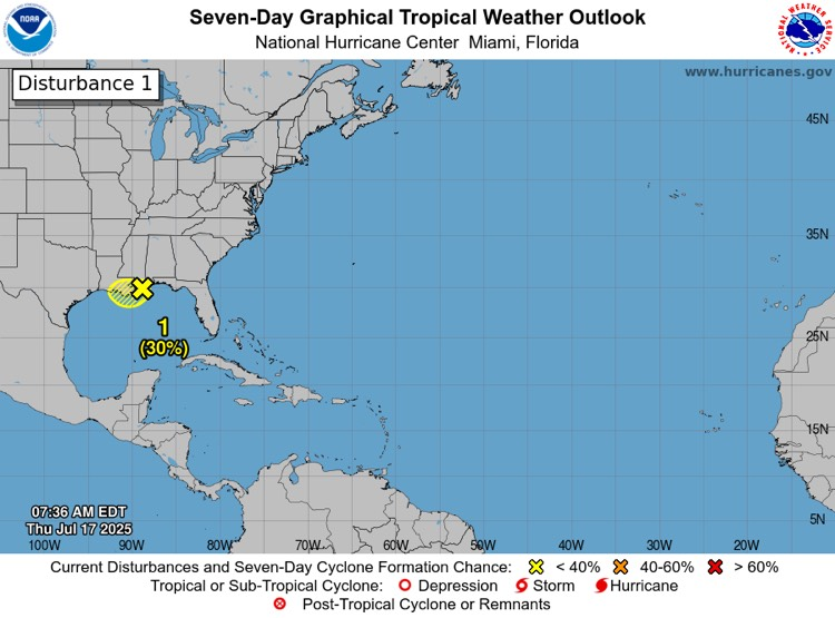
- There is a decreasing chance of tropical cyclone development as this system continues to move westward (30% chance of development still).
- It should move inland over southeastern Louisiana in the next few hours, which will further limit development.
- East Baton Rouge Parish remains under a Flood Watch until Saturday at 1:00 AM.
- The threat of a more significant flash flood event has decreased, but localized flash flooding remains possible.
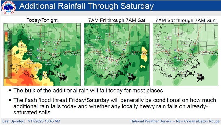
- 1-3” of rainfall is forecasted for our area today through Saturday.
- Heaviest rainfall for our area is forecasted for today with a conditional threat Friday and a decreasing threat Saturday. See rainfall total graphic below.
- A few thunderstorms could produce wind gusts of 30-40 mph.
· Rain chances decrease over the weekend and into next week, heat will once again become the main concern.

Sand and Sandbags
As a precautionary measure, City-Parish officials in coordination with BREC Parks and Recreation, have pre-positioned sand and sandbags at nine (9) locations across the parish.
*Residents should bring their own shovels to fill the sandbags.
- BREC Airline Highway Fairgrounds – 16072 Airline Highway
- BREC Alsen Park – 601 Old Rafe Mayer Road
- BREC Baker Park – 4331 Jefferson Street
- BREC Cadillac Street – 6117 Cadillac Street
- BREC Doyles Bayou Park – 7801Port Hudson-Pride Road
- BREC Flannery Road Park – 801 S Flannery Road
- BREC Hartley-Vey at Gardere Park – 1702 Gardere Lane
- BREC Lovett Road Park – 13443Lovett Road
- BREC Memorial Stadium – 1702 Foss Street
To view the complete list and find the sand location near you visit: https://gis.brla.gov/emergency.

Main Takeaways:
· Key message: The threat of a more significant flash flood event has decreased, but localized flash flooding remains possible
· High rainfall rates in storms today are likely to overwhelm drainage capacity at times, resulting in street flooding and at least a localized flash flooding threat – especially if the heavy rain moves over any urban areas.
· While coverage of heavy rainfall will be lower Friday and especially going into Saturday, some storms will still be capable of producing locally heavy rainfall. If these heavier storms move over already-saturated areas, localized flash flooding will be possible.
· As rain chances decrease over the weekend and into next week, heat will once again become the main concern