Please see the below weather update from the National Weather Service (NWS) New Orleans / Baton Rouge.
- A Freeze Warning is in effect for East Baton Rouge Parish this evening beginning at 9:00 PM through 9:00 AM tomorrow morning.
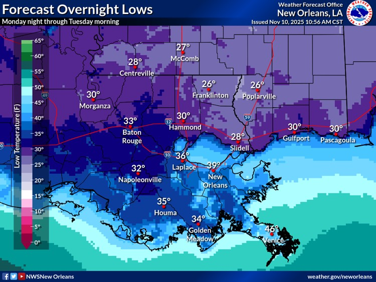
- Temperatures will fall into the mid to upper 20s along and north of I-10/12 and the upper 20s and lower 30s for more inland locations south of I-10/12.
- Temperatures will be below freezing for 5 to 10 hours along and north of the I-10/12 corridor and 1 to 4 hoursfor more inland locations along and south of the I-10/12 corridor.
- Regardless of whether air temperatures reach freezing, wind chills of near or below freezing are forecast across much of the forecast area late Monday night into Tuesday morning.

Southeast Louisiana and Southern Mississippi partners -
Here is an update concerning the cold weather threat Monday night into Tuesday morning
Overview:
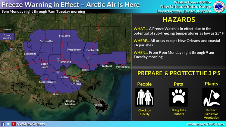
WHAT: A Freeze Warning is now in effect. Temperatures are forecast to fall to between 25 and 30 degrees along and north of the I-10/12 corridor. Temperatures are forecast to fall to between 28 and 32 degrees for more inland areas south of I-10/12 including the River Parishes, northern portions of the Bayou Parishes (Houma/Thibodaux), and parts of the Westbank of metro New Orleans. Eastbank portions of metro New Orleans and coastal portions of LA are forecast to remain above freezing. Winds will be light, so wind chills will be near the actual air temperature during the period of the Freeze Warning.
WHEN: The Freeze Warning is in effect from9 pm Monday evening through 9 am Tuesday morning
WHERE: All of S MS and SE LA, excluding most of metro New Orleans and coastal Louisiana. Further details and specific locale are provided in the graphics below.
CONFIDENCE: There is high confidence that temperatures will fall below freezing Monday night for the locations included in the Freeze Warning.
Impacts:
· Temperatures will fall into the mid to upper 20s along and north of I-10/12 and the upper 20s and lower 30s for more inland locations south of I-10/12. Temperatures will be below freezing for 5 to 10 hours along and north of the I-10/12 corridor and 1 to 4 hours for more inland locations along and south of the I-10/12 corridor.
· These conditions can damage citrus and other sensitive agricultural crops.
· Winds will be light, so wind chill temperatures will be near the actual air temperatures.
The first graphic below highlights the area covered by the Freeze Warning and the second shows the forecasted/expected overnight low temperatures across the area.