Please see the attached slides and the below weather update from the National Weather Service (NWS) New Orleans / Baton Rouge.
- The trends continue to be slightly warmer forecast conditions, however, still targeting potential freezing rain/ice accumulations for far NW areas late Sat into Sunday.
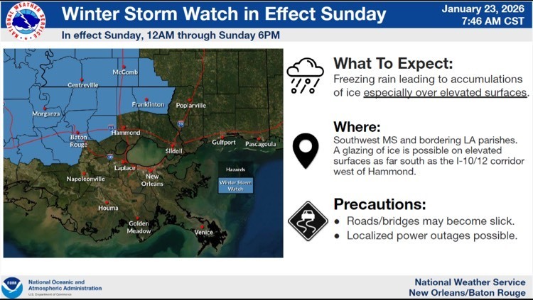
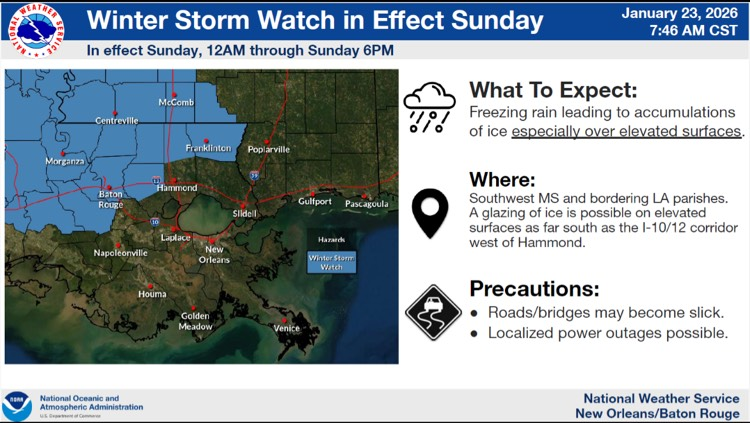
- There is a Winter Storm Watch in effect for East Baton Rouge Parish from 12:00 AM – 6:00 PM Sunday.
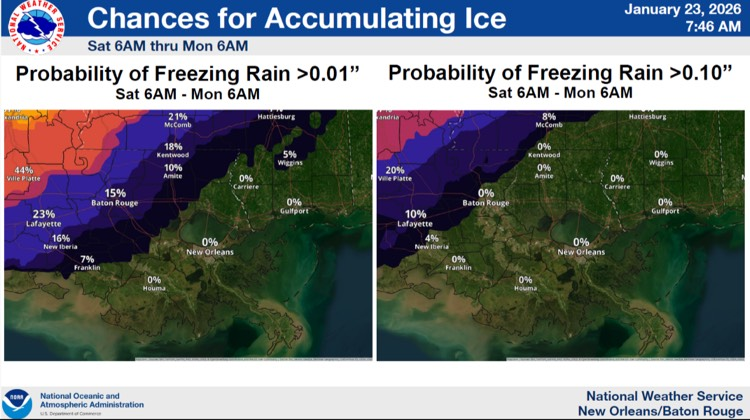
- Chances EBRP will receive freezing rain Saturday through Monday are decreasing…
- There is a 15% chance that EBRP will receive less than 0.01” of freezing rain Saturday through Monday.
- There is a 0% chance that EBRP will receive less than 0.10” of freezing rain Saturday through Monday.
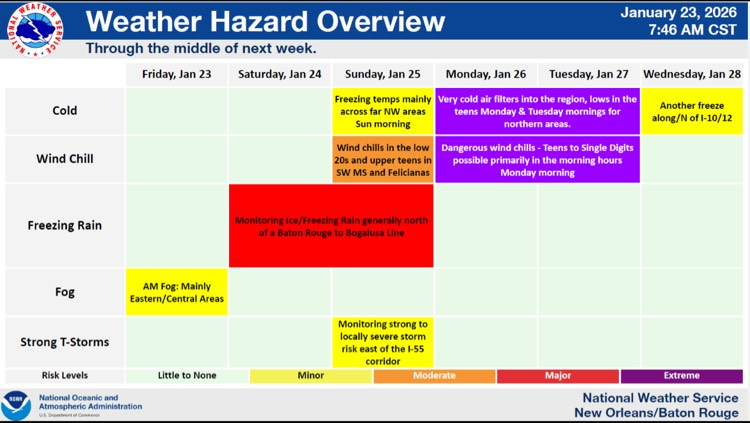
- Isolated strong to severe thunderstorms will be possible ahead of the cold front on Sunday afternoon and evening.
- Frigid, cold temperature and wind chills will lead to impacts across the majority of southeastern LA and southern MS Sunday Night through Tuesday.
- Hours below freezing:
- Monday – highs in the mid/upper 30’s N and low/mid 40’s south. 13 hours below freezing on Monday for EBR.
- Tuesday – highs in the upper 40’s to near 50. 16 hours below freezing on Tuesday for EBR.
- Wednesday – highs reaching upper 50s Wednesday. 4 hours below freezing on Wednesday for EBR.

Here is an update concerning the winter and severe weather threat Saturday and Sunday.
Changes from previous update:
- We're continuing to trend warmer with best chance of freezing rain in our far NW areas
- A Marginal Risk of severe weather has been introduced for Sunday afternoon and evening for isolated strong to severe storms along and ahead of the cold front
Overview:
WHAT: Extreme Cold with wind chills in the single digits and low teens along with a chance of freezing rain
WHEN: Early Sunday morning for freezing rain and Monday & Tuesday morning for Extreme Cold
WHERE: Along a line from Baton Rouge to Bogalusa for freezing rain and all of SE LA and S MS for Extreme cold
CONFIDENCE:
- There is still uncertainty regarding how far south freezing temperatures get Sunday morning to produce freezing rain
- There is high confidence in wind chills in the teens and upper single digits Monday and Tuesday morning
Impacts:
Freeze:
- Temperatures will fall into the upper teens and low 20s and will be below freezing for 10-20 hours for both Monday and Tuesday.
- These conditions could result in significant damage to unprotected pipes as well as citrus and other sensitive agricultural crops.
Wind Chill:
- Wind chills of 5 to 10 degrees are forecast for Monday morning and 10 to 20 degrees on Tuesday morning. These wind chills can lead to hypothermia for those without warm shelter.
Wintry Precip:
- Ice accumulation of < 0.1 inch is forecast in SW MS and Florida Parishes.
- Ice accumulation will be most likely on bridges and elevated surfaces, but even some surface roads could be affected, resulting in treacherous travel conditions.
Severe Weather:
- A MARGINAL RISK of severe weather has been introduced for areas east of I-55, mainly for Sunday afternoon and evening ahead of the cold front
- Damaging wind and tornadoes are the primary threat at this time.