Please see the below weather update and tropics outlook from the National Weather Service New Orleans/Baton Rouge.
- East Baton Rouge Parish continues to be under a Heat Advisory today and tomorrow from 10:00 AM in the morning through 7:00 PM in the evening each day.
- Heat indices near 110 degrees are forecasted for each day.

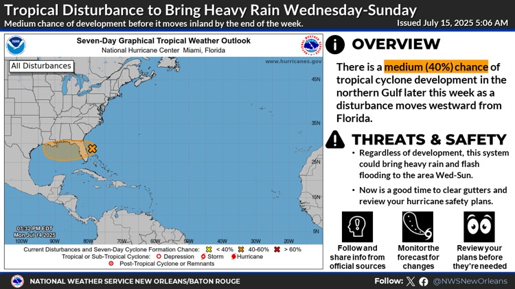
East of the Florida Peninsula into the Northeastern Gulf the National Hurricane Center is monitoringInvest 93L which has a medium chance of development later this week (40%).
· Satellite and radar data indicate that the shower and thunderstorm activity associated with the low pressure located just offshore of the east coast of Florida remains disorganized.
· This system is forecast to move westward across the Florida Peninsula today and then reach the northeastern Gulf by Wednesday.
· Environmental conditions appear generally favorable for additional development, and a tropical depression could form while the system moves across the northeastern and north-central Gulf.
- Regardless of development, this system could bring heavy rain to the area.
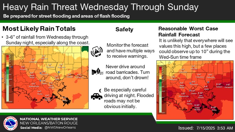
- It is too soon to say exactly how much rain will fall and where, but the current forecast calls for 3-6" across portions of southeast Louisiana and coastal Mississippi with potential for up to 10" in some localized areas during the Wednesday through Sunday time frame. However, there are still several solutions on the table including a scenario in which the heaviest rainfall stays offshore.

Southeast Louisiana and Southern Mississippi partners -
Here is an update concerning the heat threats through Wednesday, as well as an update regarding the heavy rain threat later in the week associated with a tropical disturbance forecast to move through the Gulf.
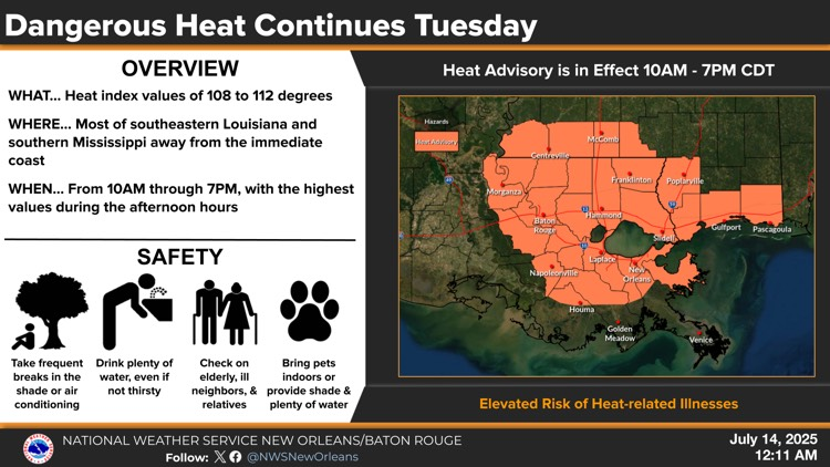
Heat Threat Through Wednesday
Overview:
WHAT: Dangerous heat conditions with heat index values near 110 degrees.
WHEN: 10a to 7pm Tuesday
WHERE: Most of southeast Louisiana and southern Mississippi.
CONFIDENCE:
· Confidence is medium to high that dangerous heat conditions will occur again Tuesday afternoon and could quickly lead to heat illness if precautions aren't taken. The biggest question will once again be how long these conditions last as isolated to scattered showers and storms once again lead to localized cooling.
· Heat impacts could linger especially west of the I-55 corridor on Wednesday, but confidence is low whether heat impacts will continue near the coast as rain chances are currently forecast to be 60-80% in the afternoon.
Heat Impacts:
· With heat index values forecast near 110 degrees, heat illness can occur quickly.
· Frequent breaks in the shade or indoors, drinking plenty of water, checking on vulnerable populations such as the elderly and unhoused, and bringing pets indoors and/or giving them plenty of water are all recommended during these conditions.
The graphics below highlight the heat advisory today.
Tropical Weather Outlook and Heavy Rain Threat Wednesday Through At Least Sunday
Changes from previous update:
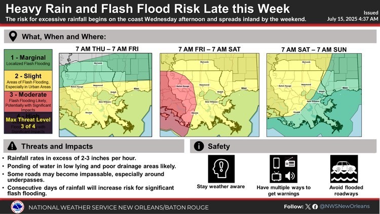
· The risk for excessive rainfall has increased across southern Louisiana for later this week. Flash flooding is becoming more likely, and a few areas could see significant impacts. However, this disturbance is still undeveloped and the forecast rainfall totals are still fluctuating so further changes to the forecast could occur.
Overview:
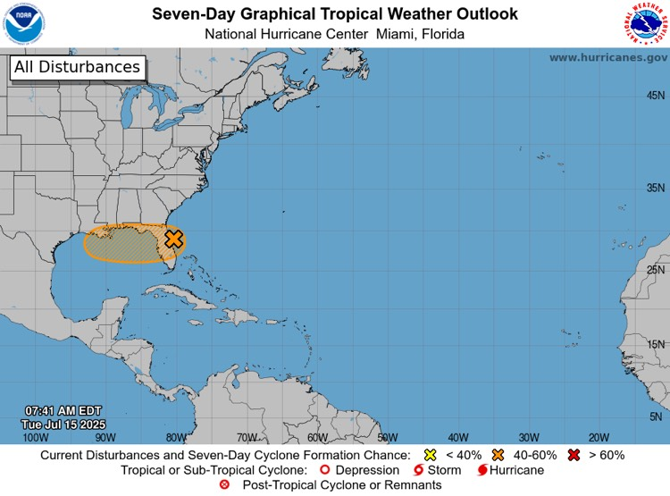
· There is a MEDIUM (40%) chance of tropical cyclone development over the next 7 days.
· This disturbance is forecast to move westward across Florida during the next day or so, and into the northeastern Gulf by late Tuesday. It will then continue to move west/west-northwest through the northeastern and north-central Gulf during the middle to latter part of this week
Confidence:
· There is low confidence that this system will develop into a tropical depression or stronger
· Though confidence is medium to high that this system will bring a threat of locally heavy rain to portions of southeastern Louisiana and southern Mississippi during the second half of this week and possibly through the weekend, confidence in the exact rainfall totals and where the highest totals will occur is currently low. The forecast rainfall totals will continue to be refined over the coming days.
Potential Impacts:
· Regardless of development, this system will bring a threat of heavy rain to southern portions of southeast Louisiana and southern Mississippi, especially along the coast.
· It is too soon to say exactly how much rain will fall and where, but the current forecast calls for 3-6" across portions of southeast Louisiana and coastal Mississippi with potential for up to 10" in some localized areas during the Wednesday through Sunday time frame. However, there are still several solutions on the table including a scenario in which the heaviest rainfall stays offshore.
· Ponding of water in low lying and poor drainage areas is likely, with potential for more significant impacts if the higher-end rainfall totals are realized.
· Tides are currently moving into a neap cycle (low range between high and low tide), which should keep any coastal flooding at bay through at least Friday
The graphics below highlight both the tropical weather outlook and rainfall threats associated with this system.