Good Afternoon,
Please see the below update from the National Weather Service (NWS) New Orleans / Baton Rouge regarding Invest 93L.
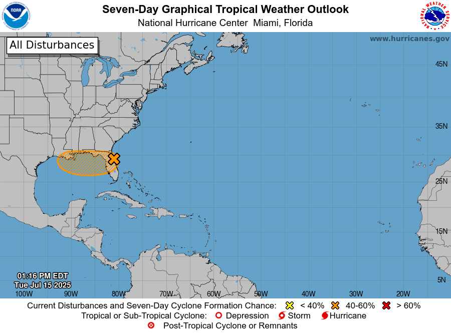
Invest 93L is currently located over the Florida Peninsula and forecasted to move into the Gulf early tomorrow
. It remains to be seen how organized it will be when it moves into the Gulf.
There is currently a lot of uncertainty on the exact track and intensity of the storm. There is still a 40% chance of development and a possibility of it intensifying into a Tropical Depression.
Once the system emerges into the Gulf tomorrow, forecasts should become clearer.
Invest 93L is currently forecasted to bring heavy rainfall to our area – exact totals are dependent on once it moves into the Gulf.
3-6” of rainfall with locally higher amounts possible for East Baton Rouge on Wednesday – Sunday.
Reasonable worst-case scenario for EBR is 6-8” of rainfall with locally higher amounts possible Wednesday – Sunday.
There is uncertainty on the exact rainfall amounts and the timing which is dependent on the organization of the storm.
Currently, the greatest threat of rainfall for EBR will be on Thursday and Friday.
Rainfall rates in excess of 2-3 inches per hour will likely lead to ponding of water in low lying and poor drainage areas at times
EBR will be under a Flood Watch beginning at 1:00PM tomorrow through 1:00AM Saturday.
River crests are extremely sensitive to exactly where and how quickly rain falls, so it is currently too soon to project whether any river flooding will occur. With rivers at base flow rates or lower (except for the Mississippi), the threat of significant river flooding is relatively low.
Main Takeaways:
There is a medium (40%) chance of tropical cyclone development in the northern Gulf late this week.
Regardless of development, the system forecast to move through the gulf will bring multiple rounds of heavy rain during the Wed-Sun time frame, with the greatest threat Thursday and Friday.
High rainfall rates are likely to overwhelm drainage capacity at times, resulting in street flooding and at least a localized flash flooding threat.
Areas that see the most rain could experience more significant flash flooding, especially if there aren’t sufficient breaks between rounds of heavy rain to allow drainage to catch up.