Please see the below weather update and tropical outlook from the National Weather Service (NWS) New Orleans / Baton Rouge.
- East Baton Rouge is under a Heat Advisory today from 10:00 AM – 7:00 PM.
- Heat indices near 108 degrees are possible.

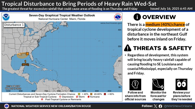
- The National Hurricane Center is continuing to monitor Invest 93L currently over the northeastern and north-central Gulf. Invest 93L is currently moving westward across the Florida Panhandle between Tallahassee and Panama City.
- There is still a 40% chance of development for Invest 93L over the next two days before moving inland.
- The associated shower and thunderstorm activity is disorganized and located mainly south and southwest of the center. This system is forecast to continue moving westward, and could emerge or redevelop over the far northeastern to north-central portion of the Gulf later today or tonight, reaching the coast of Louisiana by Thursday.
- If this system moves far enough offshore, environmental conditions over the Gulf appear generally favorable for additional development, and a tropical depression could still form over the next couple of days before the system moves fully inland by the end of the week.
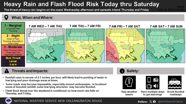
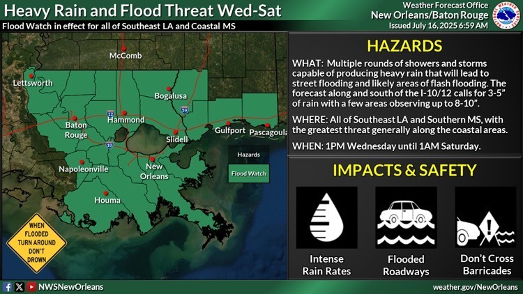
- A Flood Watch is in effect for EBR beginning at 1:00 PM today through 1:00 AM Saturday.
- Regardless of development, this disturbance moving into the northeast Gulf will bring multiple rounds of heavy rain during the Wednesday through Saturday time frame, with the greatest threat Thursday and Friday.
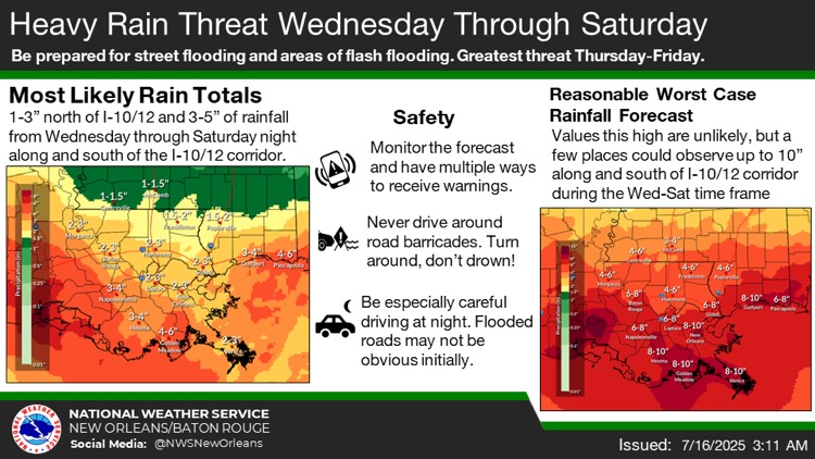
- The current forecast calls for 1-3" for areas north of the I-10/12 corridor and 3-5" of rainfall along and south of the I-10/12 corridor with the potential for up to 10" in some localized areas (especially along the coast) during the Wednesday through Saturdaytime frame. However, it is still possible the heaviest rainfall stays just offshore.
Sand and Sandbags
As a precautionary measure, City-Parish officials in coordination with BREC Parks and Recreation, have pre-positioned sand and sandbags at nine (9) locations across the parish.
*Residents should bring their own shovels to fill the sandbags.
- BREC Airline Highway Fairgrounds – 16072 Airline Highway
- BREC Alsen Park – 601 Old Rafe Mayer Road
- BREC Baker Park – 4331 Jefferson Street
- BREC Cadillac Street – 6117 Cadillac Street
- BREC Doyles Bayou Park – 7801Port Hudson-Pride Road
- BREC Flannery Road Park – 801 S Flannery Road
- BREC Hartley-Vey at Gardere Park – 1702 Gardere Lane
- BREC Lovett Road Park – 13443Lovett Road
- BREC Memorial Stadium – 1702 Foss Street
To view the complete list and find the sand location near you visit: https://gis.brla.gov/emergency.

Southeast Louisiana and Southern Mississippi partners -
Here is an update concerning the heat threat today, as well as an update regarding the heavy rain threat today through Saturdayassociated with a tropical disturbance forecast to move through the Gulf and into southeast Louisiana.
Heat Threat Through Wednesday
Changes from previous update:
- Due to more widespread cloud coverage from the marine storms ongoing and the increased likelihood that this inhibits some of the warming and higher heat indices we would see later today, the Heat Advisory has been cancelled for coastal Mississippi (Pearl River, Hancock, Harrison, Jackson), northshore (St. Tammany), and southshore (Orleans, Jefferson, St. Charles, Lafourche, Terrebonne, and Plaquemines).
- A heat advisory still remains in effect for the remainder of areas to the northwest of Lake Pontchartrain (including Baton Rouge metro) and southwest Mississippi. However, we will have to monitor trends over the next 6 hours to determine whether further adjustments to the Heat Advisory are necessary.
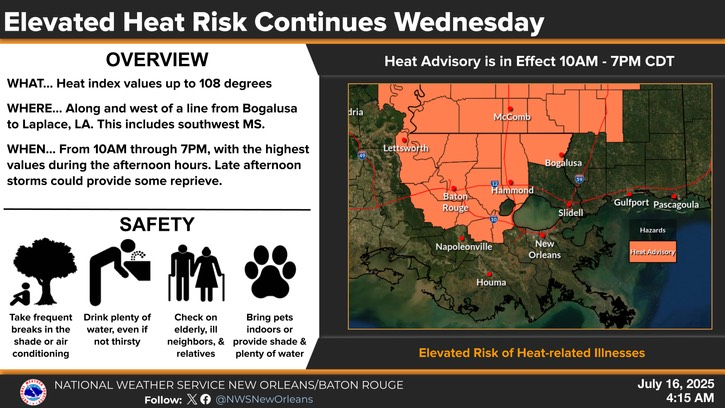
Overview:
WHAT: Dangerous heat conditions with heat index values near 108 degrees.
WHEN: 10a to 7pm Wednesday
WHERE: Areas along and west of a line from Bogalusa through Laplace, LA, including southwest Mississippi.
CONFIDENCE:
· Confidence is medium that heat indices near 108F will occur along and west of the I-55 corridor today, but confidence is low whether heat impacts will be prolonged as afternoon storms spread inland.
Heat Impacts:
· With heat index values forecast up to 108 degrees, vulnerable populations will be more susceptible to heat-related illness.
· Frequent breaks in the shade or indoors, drinking plenty of water, checking on vulnerable populations such as the elderly and unhoused, and bringing pets indoors and/or giving them plenty of water are all recommended during these conditions.
The graphics below highlight the heat advisory today.
Tropical Weather Outlook and Heavy Rain Threat Wednesday Through Saturday
Changes from previous update:
· The risk for excessive rainfall has increased across southern Louisiana for later this week. Flash flooding is becoming more likely, and a few areas could see significant impacts. However, this disturbance is still undeveloped and the forecast rainfall totals are still fluctuating so further changes to the forecast could occur.
Overview:
· There is a MEDIUM (40%) chance of tropical cyclone development over the next 2 days before this disturbance moves inland.
· This disturbance is forecast to move west/west-northwest through the northeastern and north-central Gulf today and Thursday and move inland between midday Thursday and earlyFriday morning.
· A Flood Watch is in effect across all of southeast Louisiana and coastal Mississippi beginning at 1PM Todayand continuing until 1AM Saturday.
Confidence:
· Confidence remains low that this system will develop into a tropical depression or stronger. Any development of this system would likely occur right along the coast, leaving very little time for it to strengthen before moving inland.
· Confidence is medium to high that this system will bring a threat of locally heavy rain to southeast Louisiana and coastal Mississippi, especially on Thursday and Friday.
· Confidence is medium in the forecast rain totals along the coastal areas of Mississippi and southeast Louisiana, but confidence is lower for the forecast rain totals north of the I-10/12 corridor. We will continue to monitor for any last minute trends that could shift the axis of heaviest rainfall farther north, closer to the I-10/12 corridor.
Potential Impacts:
· Regardless of development, this disturbance moving into the northeast Gulf will bring multiple rounds of heavy rain during the Wednesday through Saturday time frame, with the greatest threat Thursday and Friday.
· The current forecast calls for 1-3" for areas north of the I-10/12 corridor and 3-5" of rainfall along and south of the I-10/12 corridor with the potential for up to 10" in some localized areas (especially along the coast) during the Wednesday through Saturdaytime frame. However, it is still possible the heaviest rainfall stays just offshore.
· Ponding of water in low lying and poor drainage areas is likely, with potential for more significant impacts (such as water approaching low-lying structures) if the higher end rainfall totals are realized.
· Tides are currently moving into a neap cycle (low range between high and low tide), which should keep any coastal flooding at bay through at least Friday.
The graphics below highlight both the tropical weather outlook and rainfall threats associated with this system.